
Profile of Acting Governor of Qinghai highlights China’s focus on damming and diverting Tibet’s water – despite earthquake risks
- China’s religious policies and authoritarian control in Tibet emerge from the leadership’s strategic and economic imperatives, and those interests converged in a visit last month by the Chinese-appointed Panchen Lama to Zam (Chinese: Zangmu) dam, which supports the largest hydropower project in the Tibet Autonomous Region.
- The Acting Governor of Qinghai, Liu Ning, has a career in hydrology and is a former senior member of the official committee for the massive Three Gorges dam, the world’s largest hydropower project and most notorious dam, described by environmentalists as a “model for disaster.” His appointment highlights the high-level focus on exploiting Tibet’s water as a ‘strategic asset’ for China, including in the expansion of the South-North Water Transfer Project.
- China is planning more hydropower dams on Tibet’s major rivers, despite a proven connection between earthquakes and dams on the Tibetan plateau, one of the most seismically active areas in the world.
Chinese-appointed Panchen Lama’s visit to largest dam demonstrates China’s strategic priorities in Tibet
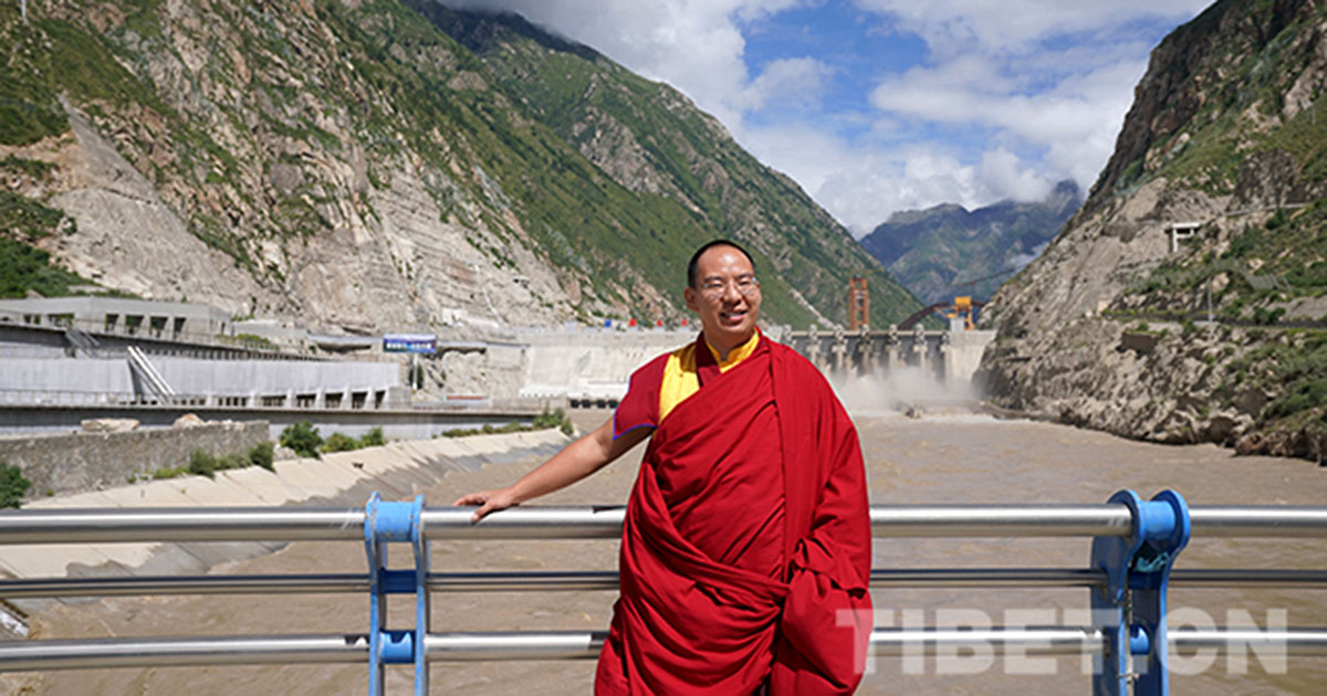
The Chinese-appointed Panchen Lama Gyaltsen Norbu is pictured by the state media at the Zam (Chinese: Zangmu) dam in Lhokha, around 155 kilometers from Lhasa.
China’s religious policies and authoritarian behavior in Tibet emerge from the Chinese government’s strategic and economic imperatives—namely securing control over borders; increasing productivity in the cities of Xi’an, Chongqing and Chengdu at the foot of the Tibetan plateau; expanding mining of the plateau’s rich resources (which include uranium, lithium and gold) in order to fuel China’s economic development; and addressing the growing scarcity of water resources in North and Northeast China with water sourced in Tibet.
These interests converged with a photo-opportunity by the Chinese-appointed Panchen Lama Gyaltsen Norbu (referred to by Chinese media in English as Gyalcain Norbu) at the enormous Zam (Chinese: Zangmu) Hydropower Project in Lhokha (Chinese: Shannan), the largest hydropower station in the Tibet Autonomous Region (TAR), during his visit there in August.[1]
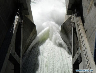
Water surges from the Zam dam on the Yarlung Tsangpo river in this image from the state media. The last remaining generator of the dam became operational in 2015, intensifying fears downstream in India given the high risk to damming upstream in one of the most seismically active areas on earth.
As a storehouse of freshwater and the source of the earth’s eight largest river systems, Tibet is a critical resource to the world’s 10 most densely populated nations surrounding the plateau. A major goal of China’s Five-Year Plan of 2016 to 2020 is to intensify the buildup of dams like the Zam on all of Tibet’s major rivers, with cascading dams on the wild mountain rivers and others stemming China’s last free-flowing international rivers such as the Yarlung Tsangpo, involving powerful state-owned Chinese consortiums.[2]
Zam is only the first of the planned six hydro dams capturing the water power of the Yarlung Tsangpo.
Damming upstream in Tibet carries great risks, particularly as the plateau is one of the most seismically active areas of the world—but the risks are being ignored by the Chinese government.[3] Dam designers are still surveying the TAR for locations where there is an upland lake and a river below that can be paired in a daily 24-hour pumped hydro cycle.
Environmental specialist Gabriel Lafitte has noted on his blog, rukor.org, that engineers have found several such locations recently, especially in Nyingtri (Chinese: Linzhi), a heavily-militarized region that borders Arunachal Pradesh in India, and where the pace of urbanization and infrastructure construction is rapid.[4]
Scientific research shows that dams of a particular size may be a direct cause of earthquakes via a process known as reservoir-induced seismicity, meaning that the weight of water behind a dam, coupled with the seeping of water into fissures in rocks below, can produce stress strong enough to worsen, or trigger, an earthquake.
The most shocking example of this was the 7.9 magnitude Sichuan earthquake in May 2008, which had its epicenter in a Tibetan area and killed more than 87,000 people. Scientists and geologists believe that pressure from the 511-foot high Zipingpu Dam, just 550 yards from the Longmenshan fault line and three miles from the epicenter[5] may have helped trigger this devastating quake. Fan Xiao, the chief engineer of the Sichuan Geology and Mineral Bureau in Chengdu, was cited as saying that it was “very likely” that the construction and filling of the reservoir in 2004 had led to the disaster. “There have been many cases in which a water reservoir has triggered an earthquake,” said Mr Fan. “This earthquake was very unusual for this area.”[6]
A research paper by a group of Chinese scientists concluded that the weight of water clearly affected seismic activity “and it is worthwhile to further study if the effect played a role in triggering the Wenchuan earthquake”, according to an abstract of the paper published in the December issue of the Chinese journal ‘Geology and Seismology’.[7]
South-North Water Transfer Project and Tibet
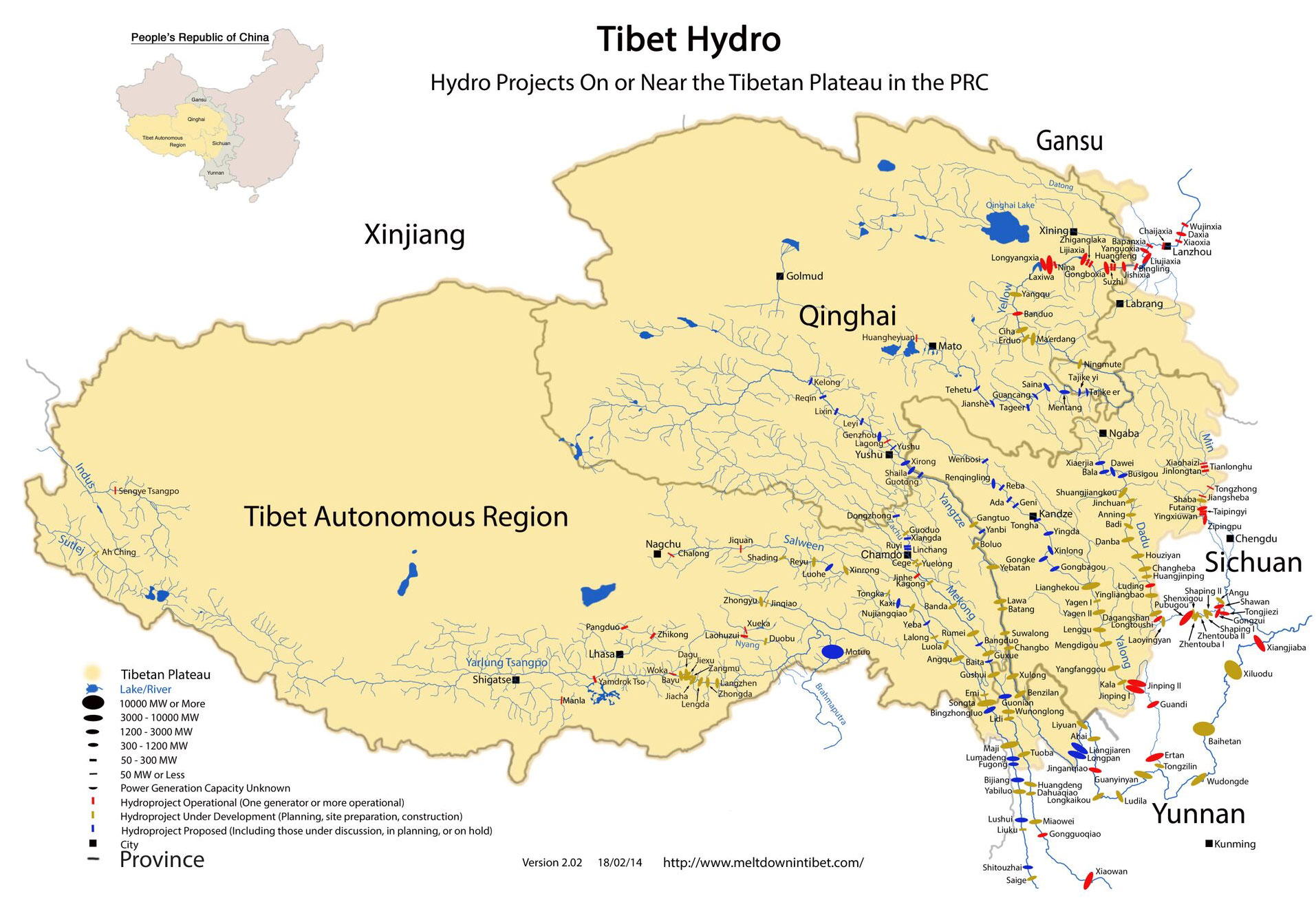
Hydro projects on or near the Tibetan plateau. Map captioned in English from author Michael Buckley’s website, www.meltdownintibet.com.
The plans for dam-building in Tibet have gathered pace despite the ‘model for disaster’ set by the massive Three Gorges dam, the world’s largest hydropower project and most notorious dam, on the Yangtze River and tributaries. This massive project set records for number of people displaced (more than 1.2 million), number of cities and towns flooded (13 cities, 140 towns, 1,350 villages), and length of reservoir (more than 600 kilometers).[8] The environmental impacts of the project are likely to get worse as time goes on, and in 2011, China’s highest government body for the first time officially acknowledged the “urgent problems” of the Three Gorges Dam.[9]
Qinghai’s Acting Governor Liu Ning, whose appointment was announced in August 2018, held a senior role in the Three Gorges dam ‘Design Office’ and has a career in hydrology.[10] He began his career as an engineer in the Yangtze River Basin Planning Office, later serving as deputy chief engineer of the Yangtze River Water Resources Commission and then as the general engineer of the Ministry of Water Resources. In 2001, Liu Ning was appointed as chief engineer of the controversial South-North Water Transfer Project, an elaborate and ambitious plan to divert water away from the upper Yangtze and into the Yellow River.
This massive project, described as the most expensive infrastructure enterprise in the world, is the largest transfer of water between river basins in history, aimed at addressing China’s severe water shortage. The two working stretches of the water diversion project can divert 25 billion tons of water a year from south to north, channeling water from the Yangtze far to the parched north of China. But the project is controversial, and the current routes have cost more than twice their initial budget. Increasingly, Chinese environmentalists and experts are arguing that the project is at a dead end, as it increases pollution and does not encourage water conservation.
Liu Ning’s previous positions working on both the Three Gorges Dam and the South-North Water Diversion project will likely ensure he plays a role in discussing a projected third canal crossing Tibet.
This projected third canal would divert water from the Yangtze in the south to the Yellow River in the north, traversing the Tibetan prefectures of Ngaba (Chinese: Aba) and Kardze (Chinese: Ganzi) in Sichuan. But it is by no means certain that these plans will go ahead, even though the engineering team had initially been due to be switched to Tibet in 2016 at the beginning of the 13th Five-Year Plan period. It would entail an influx of Chinese workers and engineers with heavy equipment into remote valleys, as well as tunneling through mountains, with the canal itself winding around the sides of mountains. The project would likely take longer than five years and would have an irreversible and devastating impact.
In an analysis of this mammoth water-diversion project, Lafitte refers to changes in China’s domestic politics since the Three Canal South-to-North Water Transfer project was first announced, saying that: “Users of the Yangtze River, all the way down to Shanghai and the sea, are increasingly protective of their river, and don’t want any more of it diverted, and the downstream provinces carry enormous clout. […] Another reason against this third canal ever being built is that the water, after flooding the richest wetland meadow pasture in Tibet, at Dzoege, will flow through the upper Yellow River, with water available to upper river provinces such as Gansu and Ningxia, maybe as far downstream as Inner Mongolia. But they will grab all the benefits, there won’t be enough flow for the more politically powerful provinces further downriver, including the heartland of China’s coal and coal-fired electricity industry, plus Beijing itself.”[11]
An editorial in The Economist argued: “The South-to-North Water Diversion Project is a test for Xi Jinping, China’s president. He frequently argues that China must stop blindly increasing GDP at the environment’s expense. And he appears to recognise that the Yangzi basin needs protecting. Under a government reorganisation in March (2018), the environment ministry took over supervision of the diversion scheme. Its new overlords should heed the advice of Mr. Zhang, the project’s first director. ‘The solution to China’s water-supply problem is conservation,’ he said in 2013. ‘Using water diversion to sustain economic development is a dead end.’”[12]
Footnotes:
[1] China Tibet News online in Chinese, August 28, 2018, http://www.xztzb.gov.cn/news/1535419327828.shtml
[2] Also see International Campaign for Tibet report, ICT Home’China’s claims in new White Paper about protecting Tibet’s environment are contradicted by increased production of bottled water from shrinking Tibetan glaciers, more dams’, August 8, 2018, https://www.https://savetibet.org/chinas-claims-in-new-white-paper-about-protecting-tibets-environment-are-contradicted-by-increased-production-of-bottled-water-from-shrinking-tibetan-glaciers-more-dams/
[3] Dr. Wang Weiluo, an engineer and geographer who is an expert on dam-building at the University of Dortmund, points out: “Dam-building raises the water level of the river which increases the pressure of the water on the ground. This raises the number of geological catastrophes especially since the valleys [of the Himalayas] are so young; landslides or rockslides will already increase as has happened in the Three Gorges dam region.” Dr. Wang Weiluo makes the vivid comparison of the Mohne dam near his university in Dortmund, Germany, which was breached during the Second World War by RAF bombers (the ‘Dambusters’). The resulting floodwave killed at least 1579 people. Dr Wang, whose work is blocked from publication in China according to the German documentary ‘Struggle for Tibet’, said: Here we see a relatively low dam, which when breached released an eight meter high flood wave. But dams in Tibet which are 400 meters high would result in unprecedented catastrophe if these were to be breached.” Dr Wang Weiluo was speaking in the film ‘Struggle for Tibet’, a documentary originally shown on German TV, written and directed by: Shi Ming, Thomas Weidenbach for WDR and NDR, in collaboration with Arte. See International Campaign for Tibet report, ‘Blue Gold from the Highest Plateau: Tibet’s water and global climate change’, December 8, 2015, https://www.https://savetibet.org/new-report-reveals-global-significance-of-tibet/
[4] See ‘Hydropowering central Tibet’, Gabriel Lafitte, posted on July 8, 2018, http://rukor.org/hydropowering-central-tibet/
[5] In Lungu County (Chinese: Wenchuan), Ngaba Tibetan Autonomous Prefecture (Chinese: Aba) in Sichuan Province (the Tibetan area of Amdo).
[6] The Telegraph, ‘Chinese earthquake may have been man-made, say scientists’, February 2, 2009, https://www.telegraph.co.uk/news/worldnews/asia/china/4434400/Chinese-earthquake-may-have-been-man-made-say-scientists.html
[7] The International Rivers Network has a compilation of sources on this issue, including: Wall Street Journal, ‘Giant Dam May Have Triggered Sichuan Quake’, February 6, 2009, https://www.internationalrivers.org/resources/giant-dam-may-have-triggered-sichuan-quake-2841
[8] Details at International Rivers Network campaign summary: https://www.internationalrivers.org/campaigns/three-gorges-dam
[9] International Rivers Network blog by Peter Bosshard, May 19, 2011, https://www.internationalrivers.org/blogs/227/chinese-government-acknowledges-problems-of-three-gorges-dam
[10] A Chinese state media report on August 7 announced the appointment, and the resignation of Wang Jianjun, who became Qinghai Governor in December, 2016. Xinhua, August 7, 2018, http://www.chinadaily.com.cn/a/201808/07/WS5b693f08a3100d951b8c9156.html . Also see: ‘Liu Ning is the acting governor of Qinghai Province, Wang Jianjun resigned from the post of governor’, Economic Times, August 7, 2018, http://district.ce.cn/newarea/sddy/201808/07/t20180807_29962920.shtml
[11] Lafitte also points out that the new wave of industrialization currently taking place in Xinjiang (East Turkestan), directly to the north of the Tibetan plateau, is a factor that could tip the balance towards the third canal which, if big enough, could divert water not only eastwards to Gansu and further down the Yellow River, but also north and west in Xinjiang. “Many aluminium smelters are being built, reliant on electricity generated by new coal and gas burning power stations using the abundant fuel supplies of Xinjiang and which China imports, via Xinjiang, from Kazakhstan to the west,” Lafitte writes in the same article. “There is only one thing missing in Xinjiang, and that is water. Much of Xinjiang is desert, its towns traditionally clustered around oases. Coal fired power stations need cooling towers that use a lot of water, likewise aluminium smelting and other major heavy industries under construction in Xinjiang will all need lots of water.” ‘Water, water everywhere’, blog by Gabriel Lafitte posted on January 16, 2015, http://rukor.org/water-water-everywhere/
[12] The Economist, ‘China has built the world’s largest water-diversion project: Channelling water from south to north does more harm than good’, April 5, 2018, https://www.economist.com/china/2018/04/05/china-has-built-the-worlds-largest-water-diversion-project
![]()